1. If Every State Had Their Own Halloween Costume
If you were ever wondering what each state would dress up as for a sexy Halloween costume contest, we have that answer with this hilarious map.
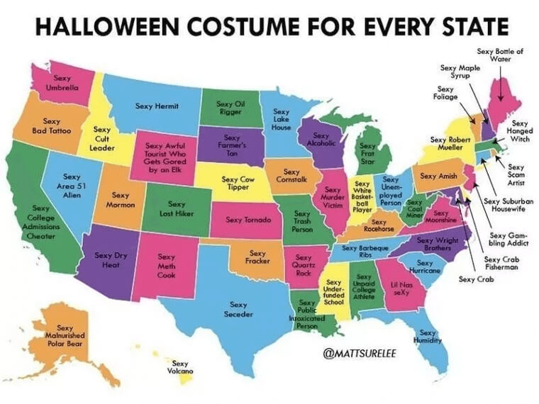
Some of these make sense and some are just awful. We all know the Washington State rains a lot, so why not be a sexy umbrella for Halloween? But Ohio's sexy unemployed person? That's harsh.
2. Is Pop Music Really That Popular?
Until looking at this map, we thought that pop music was being played constantly in almost every state, but now we're not sure.
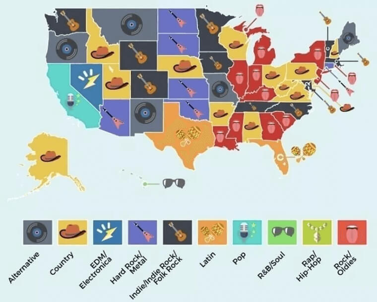
According to this photo, people are much more into country music and rock/oldies. The only state that seems to be playing pop music, is California. This map can't be right, but the graphics are awesome!
3. A Dad Joke
You don't have to be a genius to know what's going on here. The person who made this map was obviously a dad since this photo is a perfect example of a terrible dad joke.
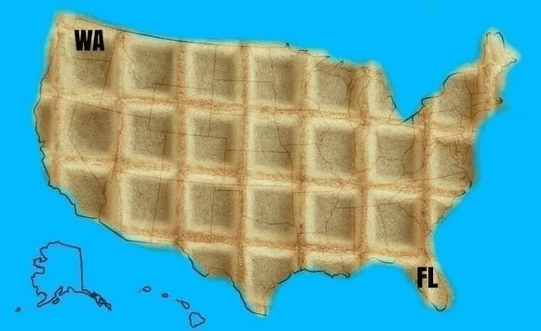
This dad thought it was hilarious to write the initials of Washington State and Florida on a U.S. map and make all the states look like waffles.
4. Indiana Is Pretty Dangerous
Whoever created this map is clearly under the illusion that Indiana is the most dangerous state out of all 50 states in the U.S.
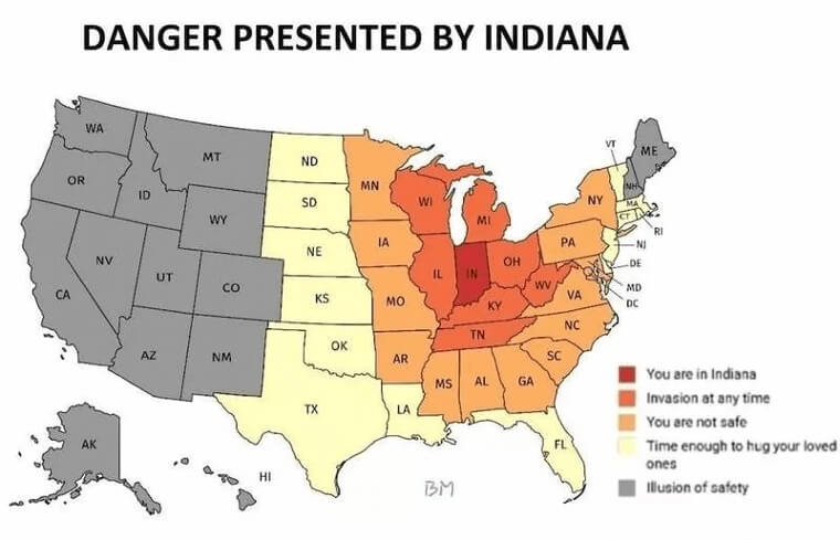
According to the map, states that are close to Indiana are still pretty unsafe, and the ones further back are colored gray, having "an illusion of safety" (because Indiana is still close by).
5. No One Is Reading This Map
At first glance, this map is very confusing - but don't worry we'll explain. The person who designed this was trying to be funny.
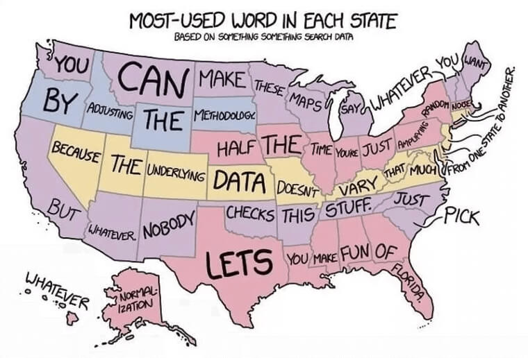
If you actually read what the words say from left to right, it's saying that the data will be the same for a U.S. map of "most used words." We will point out though, that somebody doesn't like Florida very much.
6. Who Has The Most Karens
And now for the most important map of all—which state has the most populated with Karens? A "Karen" is a woman who feels entitled and thinks everyone needs to agree with her opinions or else she'll complain.
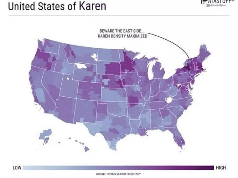
Most of us are familiar with this term and might know a few Karens personally. How many do you know in your state?
7. If You Want To Understand American Girls
If you want to know what kind of American girl you are, check out this fun map. It shows what type of girl you are based on your state.
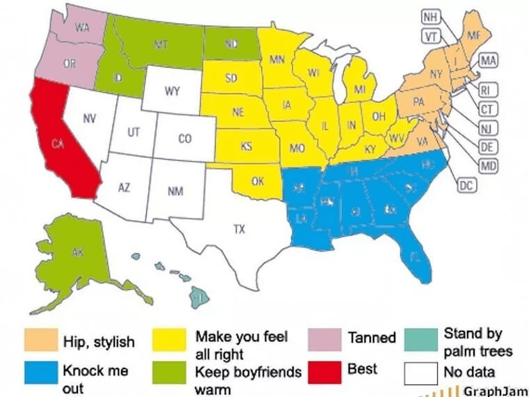
Apparently, all the girls on the East Coast are hip and stylish, while the ones from Hawaii stand near palm trees all day. Sounds about right to us.
8. Every Stereotype Possible
Warning, stereotypes alert! We've seen several versions of these maps throughout this list, so there's definitely some overlap. Between "Hollywood, baby!" (California), "Wizard of Oz" (Kansas), and "potatoes" (Idaho), the map is as eye-rolling as you can get.
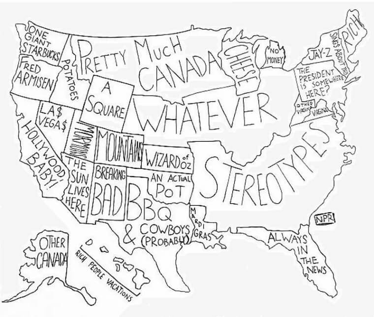
The person who drew this map was so lazy, he just put the word stereotypes for the whole South. Ridiculous!
9. When You Ask Your Teenager to Make A Map Of The US
We all know that our teenagers are immature, and this map only confirms that statement. When one mom asked her teenage son to design a map of the U.S., this photo was probably not what she had in mind.
Her son gave her a normal map, but with a few adjustments, adding some nonexistent bathroom-related destinations.
10. State Slogans
Now here's a fun map. If every state had its own slogan, this is what it would be. Before you start getting defensive, these slogans are meant to be a joke and what's written on here are mostly stereotypes.
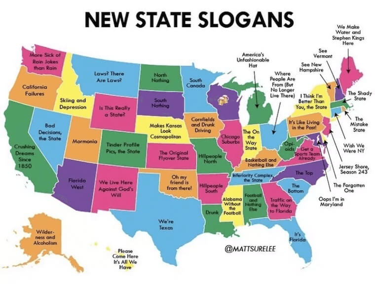
The only one that's really true is New York's - every New Yorker pretty much thinks that New York is the only important state in America.
11. Yikes, What Is Everyone Googling?
If you were ever wondering what people are searching for on the internet in each state, we got you covered.
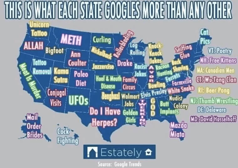
From the looks of this map, people seem to search for a whole range of things, from knock-knock jokes to conjugal visits. And maybe it's just us, but we're starting to worry about the people of Texas.
12. That's A Bit Too Literal
Do you know that one friend of yours that always makes really lame jokes? This is a classic example of a joke she would make.
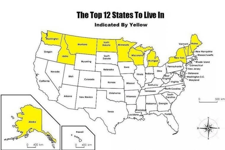
The title of this map is "The Top 12 States To Live In," except by "top" it's not referring to something that's the best. It literally means the 12 states that are located on the map. Terrible.
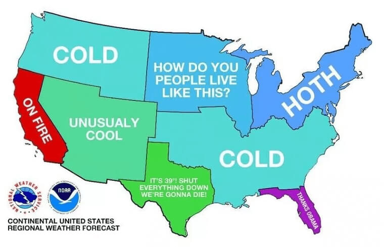
13. The Real Weather Map
This map is one of our absolute favorites - it's funny and the illustration is amazing! The weather in America varies from season to season, but this map pretty much nailed it.
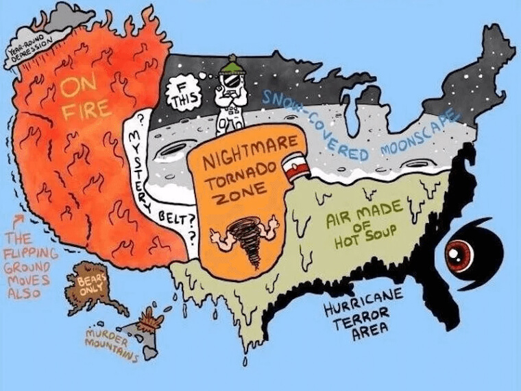
Between the snow, tornados, wildfires, hot air, hurricanes, and earthquakes, the United States really has a little bit of everything.
14. 50 Shades Of Blue
This map is by far one of the most random maps on this list. What we're seeing here is the United States of America in different shades of blue - only there isn't a reason as to why some states are darker or lighter than others.
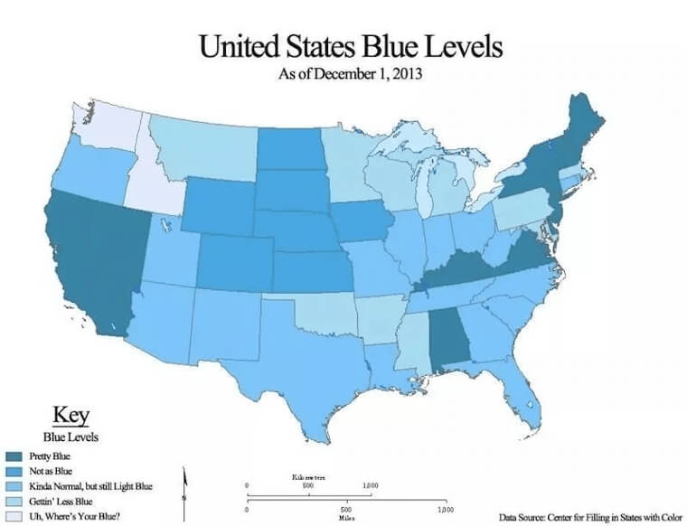
Maybe the person who made this was bored, and blue is his favorite color.
15. The Most Important Map
Listen up, everyone! We know you all want to option of going topless so you probably take a look at this map as a reference.
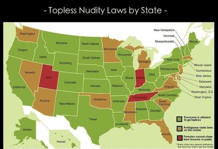
For women living in Utah, Indiana, or Tennessee, we're really sorry but you're not allowed, but for everyone else, there's a good chance that you can.
16. Most Common Language Map
What's the most common language spoken in America? You guessed it - English. The creator of this map wanted to do something funny and made a map pointing out the languages spoken in the U.S.
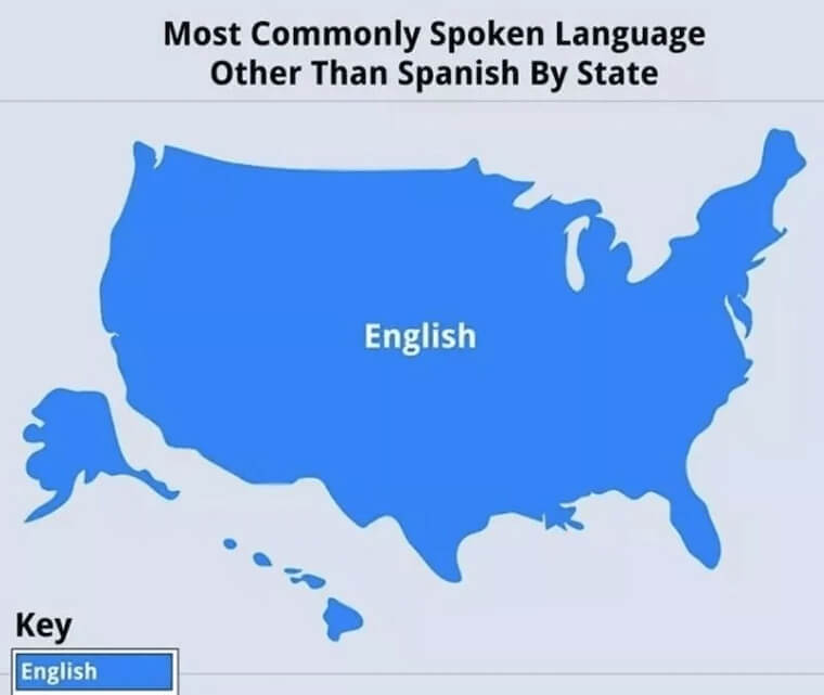
Obviously, there's only one, so he wrote English across the whole map. The "key" section on the bottom left corner was a nice touch.
17. Kim Jong Un's Plans For America
Titled "Kim Jong Un's Plan for America, " this map is honestly quite serious. This photo came straight from a North Korean war room and was leaked a few years ago.
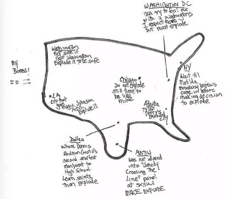
It shows which cities Kim Jong Un planned to target with his nuclear weapons. Thankfully this plan has never been finalized, but who knows what will happen in the future!
18. Reasons To Close School
So what does it really take for schools to shut down in your state? It all depends on where you live in the U.S. That's because different parts of the U.S. have different climates.
While some areas get very cold and snowy like parts of the Northeast, the West Coast is way more likely to have wildfires.
19. The Map of Shame
Isn't this one fun? If you ever wanted to know what your state is worst at, check out this map.
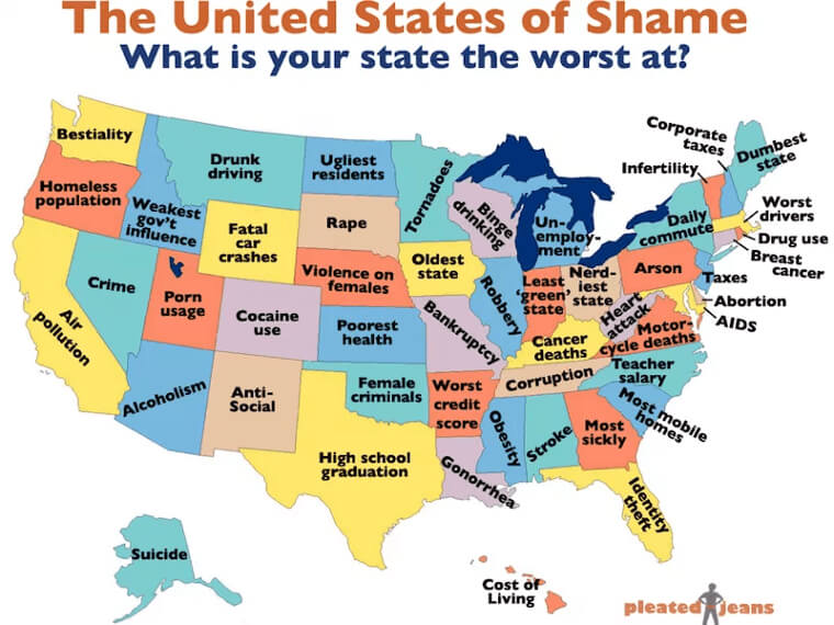
Let's hope there's no actual evidence to support the things written on here because most of them are absolutely awful. We'd especially feel pretty bad if you live in Louisiana or Michigan after reading this.
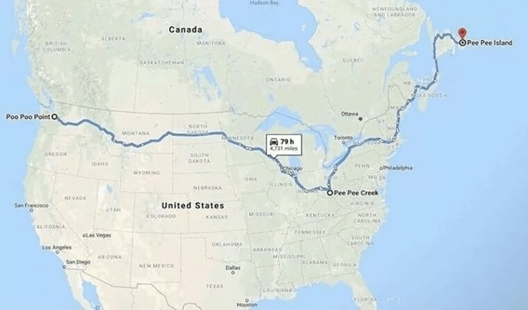
20. Town Names That Sound Dirty
Before you start wondering if these names are actual towns, we're here to tell you that they are.
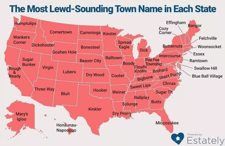
We know it's hard to believe, and while we have no idea why anyone would call their town Rough and Ready or Wankers Corner, somebody did, and they probably thought they were being hilarious. We'll admit, these names are funny and original.
21. Who's Is Bigger Competition?
Let's imagine for a minute that the 50 states had a competition to see what thing is the biggest in their state. According to this map, there seems to be a huge range between normal to really crazy.
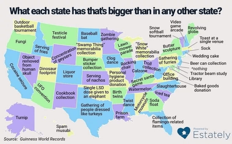
It's cool that Tennessee has the biggest watermelons, but why are people in Texas gathering to dress up as turkeys?
22. Where People Are Almost Finding Love
If you're looking to find love, get off of Tinder because this map is way more helpful. According to this photo, you can see the spots in each state that have the most "missed connections."
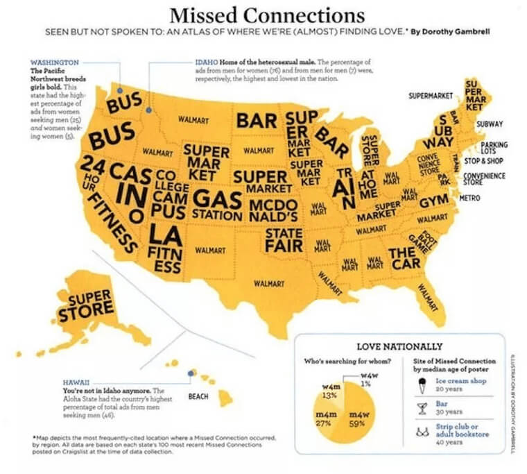
This means that people saw each other but missed out on meeting them. So the next time you want to meet the love of your life, we suggest consulting this map first.
23. Who Here Has A Toe Fetish
This map brings up a serious point that we definitely never thought about before - what's the deal with some states having toes in their flags?
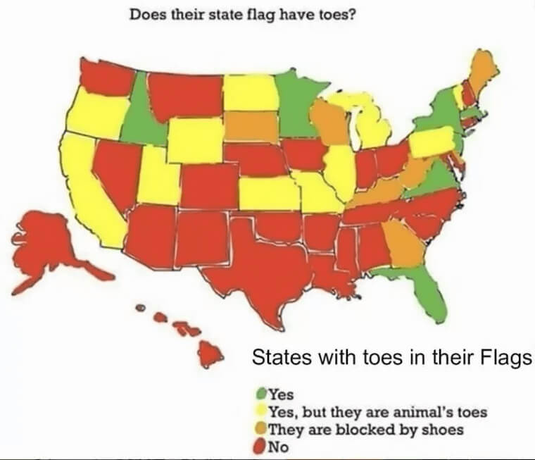
According to this map, seven states have toes in their state flags, while a whole bunch of others have animal toes or shoes. After looking at this photo we're starting to wonder - does America have a foot fetish?
24. Steamed Ham Anyone?
Many of you have watched the episode on The Simpsons, but did you know that this map is actually true.
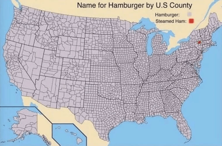
While pretty much everyone calls bread with a meat patty hamburgers, there's one place in New York that called it something else. Believe it or not, In Albany, hamburgers are called "steamed hams." Weird.
25. America, According To Australians
Turns out that Americans and Australians might have a bit more in common than either one realized. Seems like geography isn't either one's strongest skill.
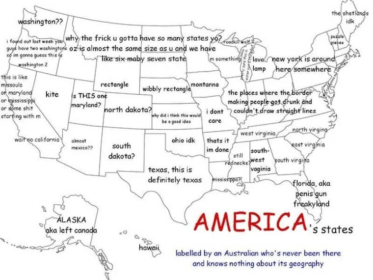
This hilarious map shows how Australians think about the United States. How much do you think they got right about it?
26. Map Of Quarantine Activity
How many of us had a lot of time on our hands in quarantine last year? This map lets us know what people were doing during that time in every state.
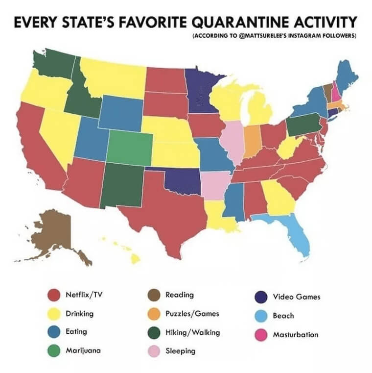
Obviously, this isn't accurate, but the activities are pretty relatable. According to the map, Netflix and TV was the most popular activity and we definitely agree.
27. Some States Eat Weird Food
As it turns out, Americans eat some pretty weird-sounding food and the food varies from state to state. How many of us can say that we've eaten gooseneck barnacles or a green chile sunday?
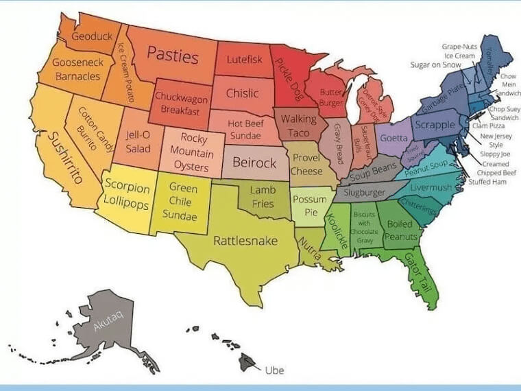
Not many, unless you're from Oregon or New Mexico. Let's just hope those slugburgers in Tennessee don't have actual slugs in them.
28. Monsters That Will Scare You
If you were ever curious about the possible monsters that could show up in your state, this map will let you know all the details. Artist Mark Adams took his ideas from different legends that were told over the years.
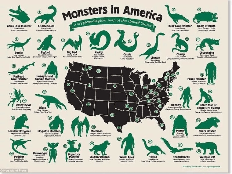
For example, if you take a look at Louisiana, legend has it that the Honey Island Swamp Monster (a seven-foot, ape-like creature) was seen in St. Tammany Parish.
29. The Kevin Map
Have you ever been curious who the famous Kevin is from every state? Who doesn't want to know which Kevin made it big in their hometown?
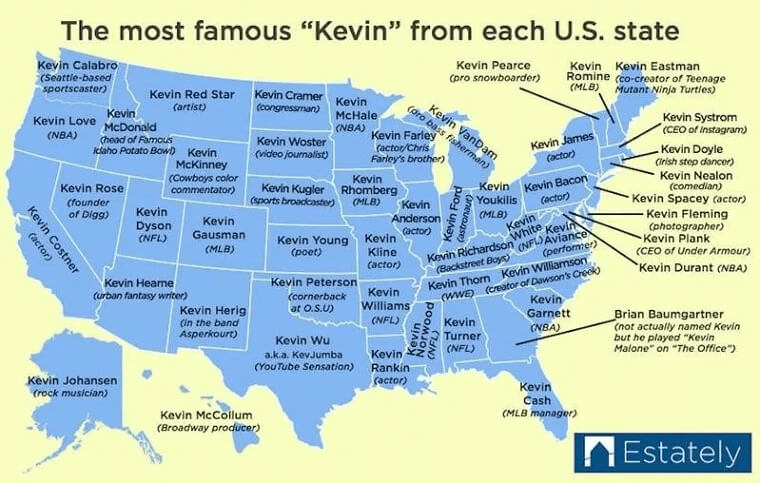
Some of them are very well-known like Kevin Bacon or Kevin Garnett, and the funniest one is the guy who played the character Kevin on the TV show, The Office.
30. If America Had No Land
This one is pretty explanatory, to say the least. But if you're still not sure why the map is solid blue, take another look at the title.

The name of this map is "If America Had No Land, " and that's exactly what you're looking at. If there was no land, there would just be a large body of water.
31. The Rest Of America To New Yorkers
New Yorkers are notorious for thinking that their state is the only one that matters. Not only that, but some New Yorkers don't even care to know about the other 49 states in their country, because they are so inferior to them.
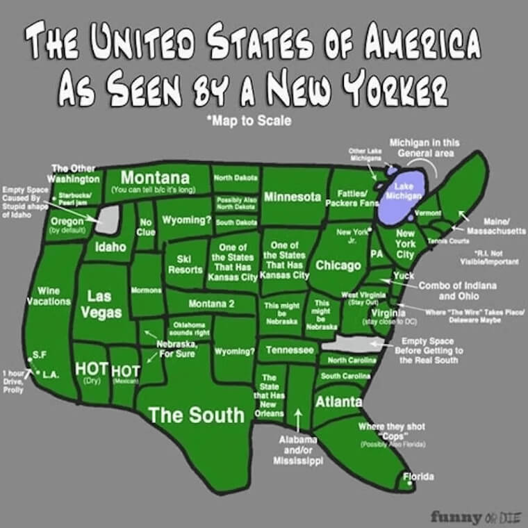
That's why this map was created - for a funny take on how New Yorkers see the rest of America.
32. D List Celebs We Shouldn't Care About From Every State
While it's not something we ever thought about after looking at this map, we can't help but wonder why Americans are looking up D-list celebrities.
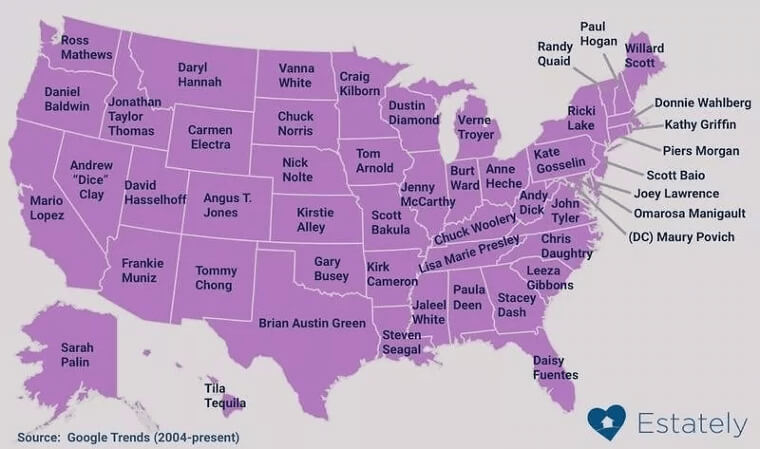
Tila Tequila hasn't been big since the 2000s, and how many people care about Chris Daughtry anymore? He was on American Idol 15 years ago! We're in 2021, not 2001.
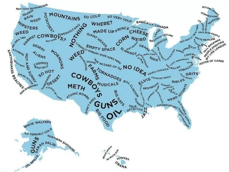
33. How Alaska sees the US
When we all learned geography in school, Alaska seemed very small. The rest of the states needed to be magnified, and there was never enough room for Alaska to fit to scale.
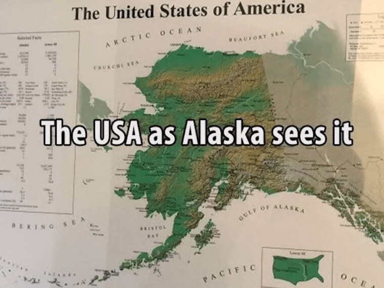
The truth is, Alaska is huge and not some tiny dot on our elementary school wall maps. This map shows how Alaskans see the U.S., and it's pretty hilarious.
34. Is Dang A Popular Word?
Weren't you just dying to know which Americans use the word "dang?" This elaborate color-coded map spells it out for us quite easily - the word is most popular in the South.
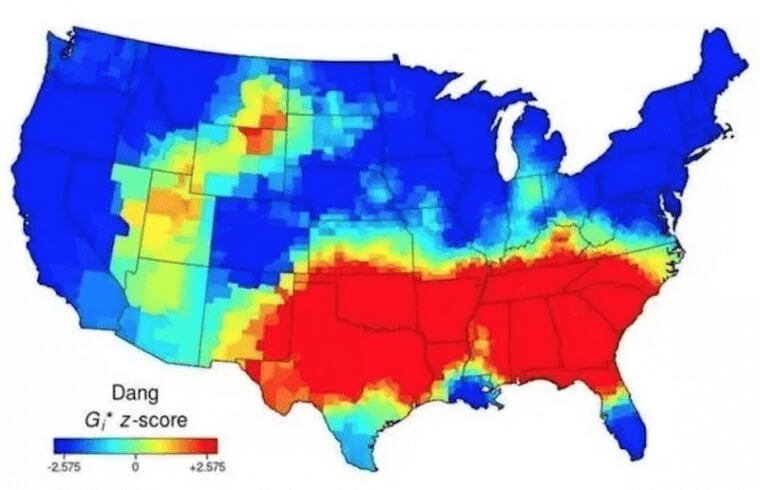
And while the rest of the map is mostly blue, there seems to be a "dang" hotspot in parts of Montana and Wyoming.
35. Where's the Good Pizza?
This map is just as accurate as it is funny. Everyone knows that the best U.S. pizza is in New York and that it's kind of the only place with good pizza. This map is basically saying that with two exceptions.
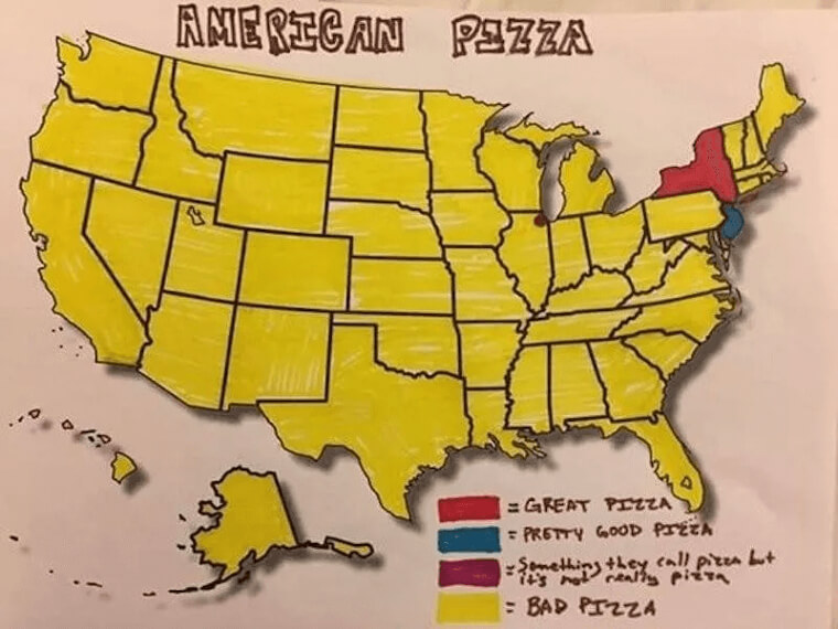
New Jersey pizza is almost as good (probably because they're so close to the pizza king state), and Chicago sells deep-dish pizza, which isn't really pizza but we will agree that it tastes good.
36. U.S. Map, The British Version
Here's a fun map of how Brits see Americans. After looking at this photo, a lot of these things are random facts about each state but they definitely don't represent the state as a whole.
Still, it's not wrong that cheese is big in Wisconsin and Obama is from Illinois. But White Walkers in Alaska? At least it made us laugh.
37. Surviving The Zombie Apocalypse
As you know, there's always a possibility that zombies may attack the U.S. It's been a topic of discussion for decades, and someone finally created a map with his zombie apocalypse survival predictions.
According to this photo, It appears that the Midwest is most likely to survive an apocalypse, but we can't say the same for Texas.
38. Who Doesn't like the Beatles?
If you were wondering what this map is about, it's showing which two things are more popular, and the data seems to show that The Beatles are more popular than Jesus.
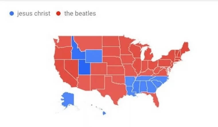
f you couldn't tell by now, the blue states on the map are a bit more conservative, but hopefully, they will be convinced. The Beatles are awesome!
39. All Roads Lead To Rome
How many of you know the saying, "All roads lead to Rome?" Well, the guy who made this map certainly seemed to agree with that statement quite literally!
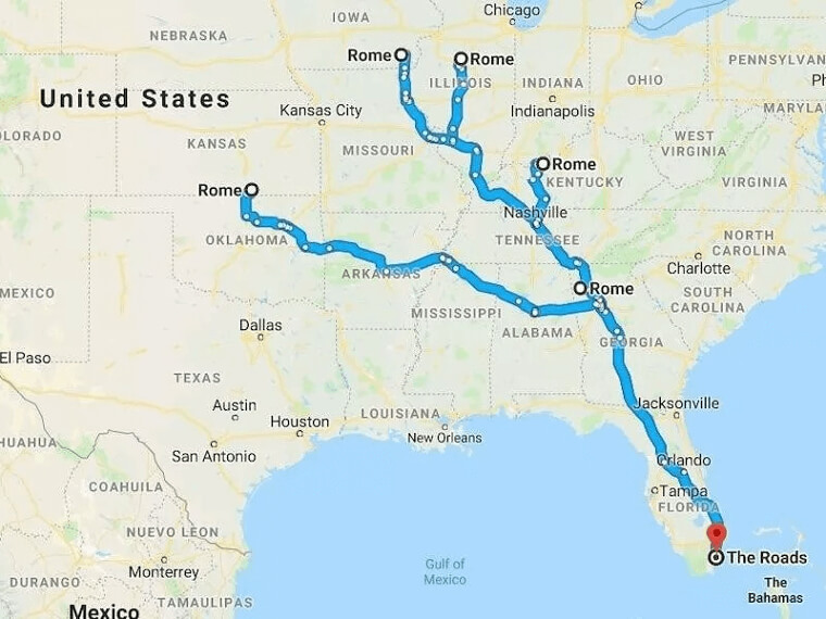
He made the starting point "The Roads," a neighborhood in Miami, Florida, which then split into five different Rome destinations in Kansas, Iowa, Illinois, Kentucky, and Georgia. Genius.
40. Which States Do You Know?
This map took a poll of the most and least remembered states, and if you haven't noticed by now, most people outside the U.S. don't seem to know about the states in the Midwest (sorry midwesterners!).
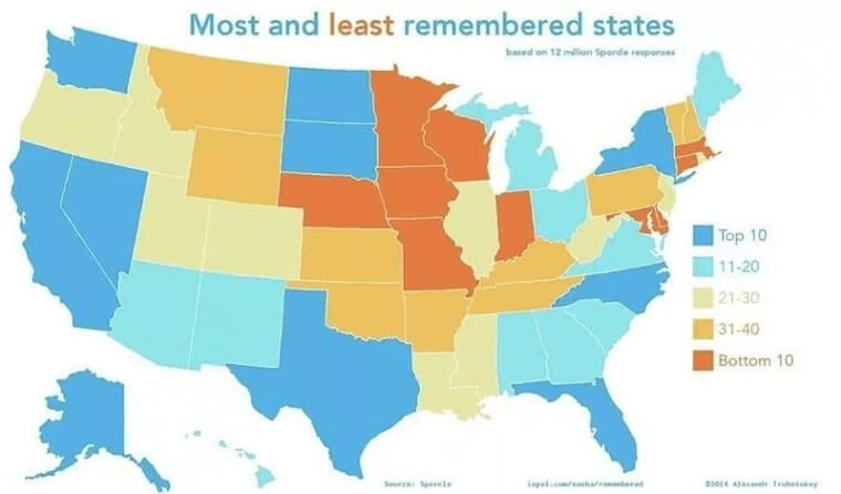
That's probably because places with big cities like New York, California, and Florida are more popular, and people don't usually travel to Iowa on their first U.S. trip.
41. Dangerous Animals To Be Afraid Of
On a scale of one to ten, how scared are you after seeing this map? It shows which land predator is in what state and how many there are.
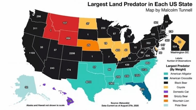
According to the data, black bears are found in more than half the states, but we'd be more worried in Colorado than in Kansas. And did you know that there were mountain lions in the U.S.? Crazy.
42. Scary Stuff In Every State
Well, if you thought the last map was scary, get ready for this one. This map shows the really scary stuff that you'll find in every state, and it will make you want to run for the hills.
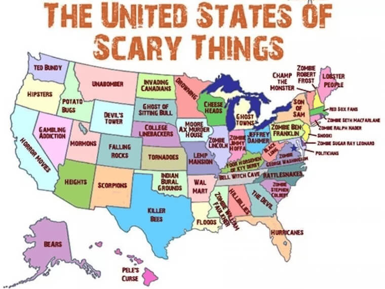
There's nothing scarier than the hipsters in Oregon or the lobster people in Maine. Yikes!
43. How To Spell 'Color'
How do Americans spell "color?" That's what this map is essentially all about. Similar to the Most Common Language map we saw earlier, the guy who made this map followed the same idea.
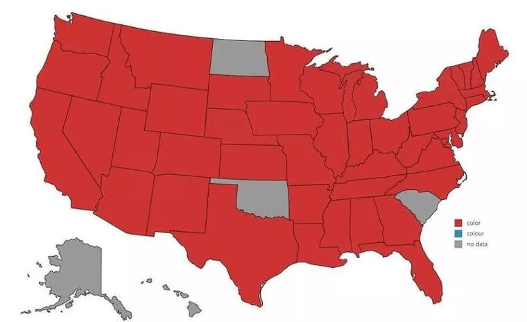
The Brits spell it with a "u" (colour), but we all know that's not the correct American English spelling.
44. Why Did You Call It That?
Getting back to town names, here are some of the strangest ones in every state. We're not sure who came up with these, but they sure are weird and hilarious.
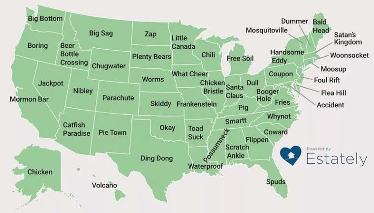
We're guessing that whoever came up with Bored must have been bored in Oregon, but we don't even know where to start with Toad Suck, Arkansas.
45. If Each State Was A TV Show
In case you wanted to know which TV show best describes which state, this the perfect map for you. Titled "If Each State Was a TV Show" you'll be able to find your hometown state and see if the TV show is accurate.
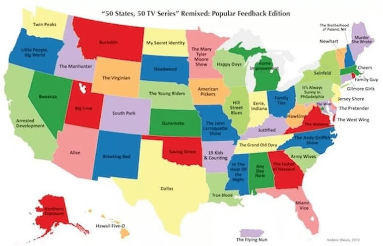
And we must say, some of them are pretty good. No one will argue that New York would be Seinfeld and Louisiana would be True Blood.
46. The 'I Don't Know Why We Made This Map' Map
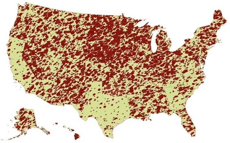
What is the point of this map? We're guessing that someone got bored and made an "I Don't Know Why We Made This Map" Map.
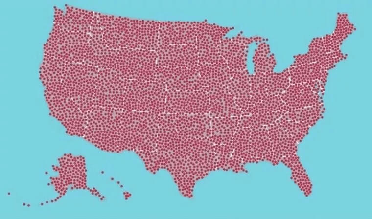
There's nothing more to understand besides that someone made a map of the United States consisting of 700 red dots. Maybe the point of this was for people to ask why it was made. Who knows.
47. Every State's Secrets Revealed
Here's some juicy gossip. Each state's biggest secrets are revealed on this map, and some of this stuff is super embarrassing.
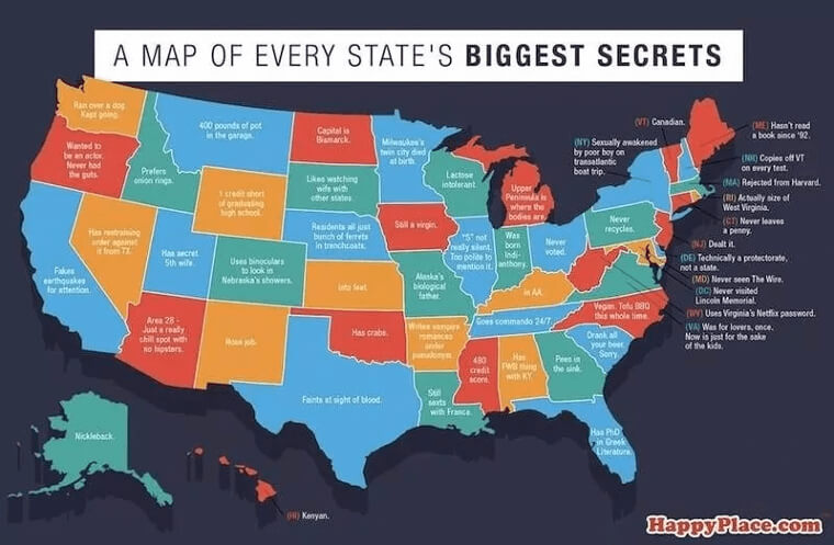
Apparently, Idaho actually prefers onion rings to french fries, Wisconsin is lactose intolerant, and California fakes earthquakes for attention. This is shocking, but we knew someday the truth would come out!
48. The Most Popular Word Is...
How many of you are surprised that the word "the" is the most common word used in every state?
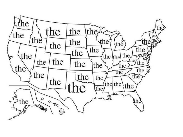
The guy making this map figured he should think a bit out of the box and be so silly even the most cranky person would crack a smile. Well, it worked for us.
49. Every State In Relation To Virginia
Is this map the most helpful? Maybe not, but it's pretty funny. If you wanted to see a map where every state is named related to Virginia take a look.
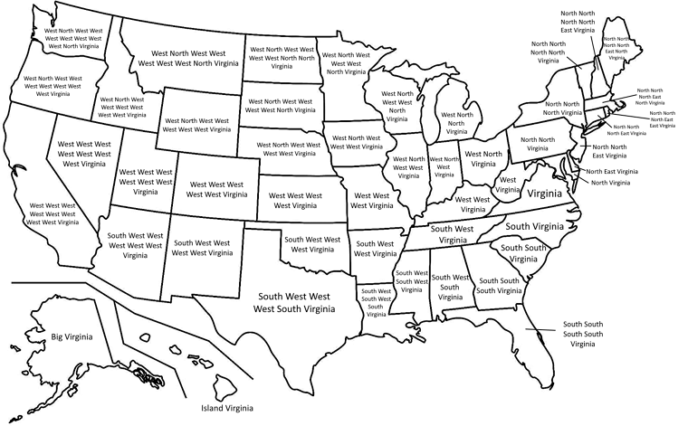
Why should it be that only one state has a name referring to where it is in relation to Virginia? "North North North North East Virginia" or "South West South Virginia" sound like lovely state names, don't you think?
50. Never-Ending Names For Your "Member"
If there was a competition for the dirtiest map on the list, this one would take the cake.
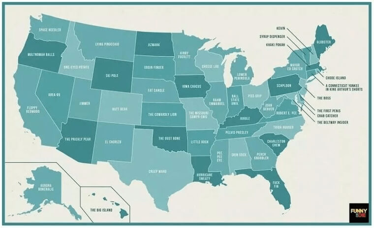
The map tells us what men call their "member," in every state, and the joke is that the names have to do with each state, like "little rock" for Arkansas or "cheese log" for Wisconsin. Clever!